Quick Answer
Karahan Tepe occupies a limestone plateau in the Tektek Mountains at 690 metres elevation, in a region that was dramatically wetter and more vegetated during the Pre-Pottery Neolithic (9600–8000 BCE) than it is today. The site’s location on high ground offered commanding views, defensible terrain, and proximity to diverse ecological zones supporting gazelle, wild cattle, and extensive plant resources. The local limestone — Eocene and Miocene formations — is relatively soft when freshly exposed, making it workable with stone tools and explaining why the builders carved their monumental structures directly from bedrock rather than building from stacked stone. A large water cistern on the northern knoll reveals the builders’ concern with managing a scarce resource in an already marginal environment. The landscape hasn’t been static — climate change and human activity have profoundly altered the region over 11,000 years.
You cannot understand Karahan Tepe without understanding the land it sits on. I have been guiding tours across Turkey for 25 years, and one thing I have learned is that ancient people did not choose their sacred sites at random. The landscape speaks, and the builders listened.
Every time I drive out to Karahan Tepe from Şanlıurfa — a journey I have made regularly since 2020 — I watch the terrain change. The flat agricultural plain gives way to rolling limestone hills. The vegetation thins. The air becomes drier. By the time you reach the Tektek Mountains, you are in a different world. Understanding that world is essential to understanding why Karahan Tepe exists where it does.
Two Plateaus, Two Sites
Göbekli Tepe and Karahan Tepe occupy different geological platforms. Göbekli Tepe sits at 780 meters elevation on the Germuş Plateau, while Karahan Tepe stands at roughly 690 meters on the Tektek Plateau. Both are built on limestone bedrock — Eocene and Miocene formations — but the topographic character of each site differs.
Göbekli Tepe’s hill is broad and gently rounded, visible from a distance. Karahan Tepe’s ridge is more elongated, oriented roughly north-northeast to south-southwest, and feels more enclosed. The surrounding terrain at Karahan Tepe is more rugged, with deeper valleys and more pronounced ridge lines. This geological difference likely influenced the builders’ architectural choices: Göbekli Tepe’s structures were built upward from the surface, while Karahan Tepe’s were carved downward into the bedrock.
Climate Then and Now
One of the most important findings from geomorphological research is that the climate during Karahan Tepe’s occupation was significantly different from what you experience today. The Tektek Mountains during the Pre-Pottery Neolithic — roughly 10,000 to 8,000 BCE — were more humid than the present, with richer vegetation and more diverse wildlife.
This period spans two critical climatic phases: the Bølling-Allerød interstadial (a relatively warm and wet period) and the Younger Dryas stadial (a sharp return to near-glacial conditions). Temperature fluctuations of 2 to 3 degrees Celsius do not sound dramatic, but in a marginal environment like the Tektek Mountains, even small climatic shifts can transform the landscape.
The transition from wetter to drier conditions may have been a factor in the eventual abandonment of these sites. Evidence of erosion and terrain changes over the roughly 1,300 years of occupation shows that the landscape was not static — it was shifting under the builders’ feet.
The Water Problem
Water scarcity is identified in the research as a major environmental challenge for both sites. Göbekli Tepe lacks nearby permanent water sources, and Karahan Tepe is no better served. Today, the landscape is dry steppe with seasonal rainfall. In the Neolithic, while conditions were wetter, reliable water access would still have required knowledge and planning.
The large basin-shaped water cistern on Karahan Tepe’s northern knoll — roughly 3 meters wide — may represent one solution. Whether this was purely practical (collecting rainwater) or served ritual purposes as well (reflection pool, purification basin), it demonstrates that the builders took water management seriously.
The possibility that prolonged drought contributed to the abandonment of these sites adds an environmental dimension to what is often presented as a purely cultural story. These were people responding not just to spiritual impulses but to the practical realities of survival in a challenging environment.
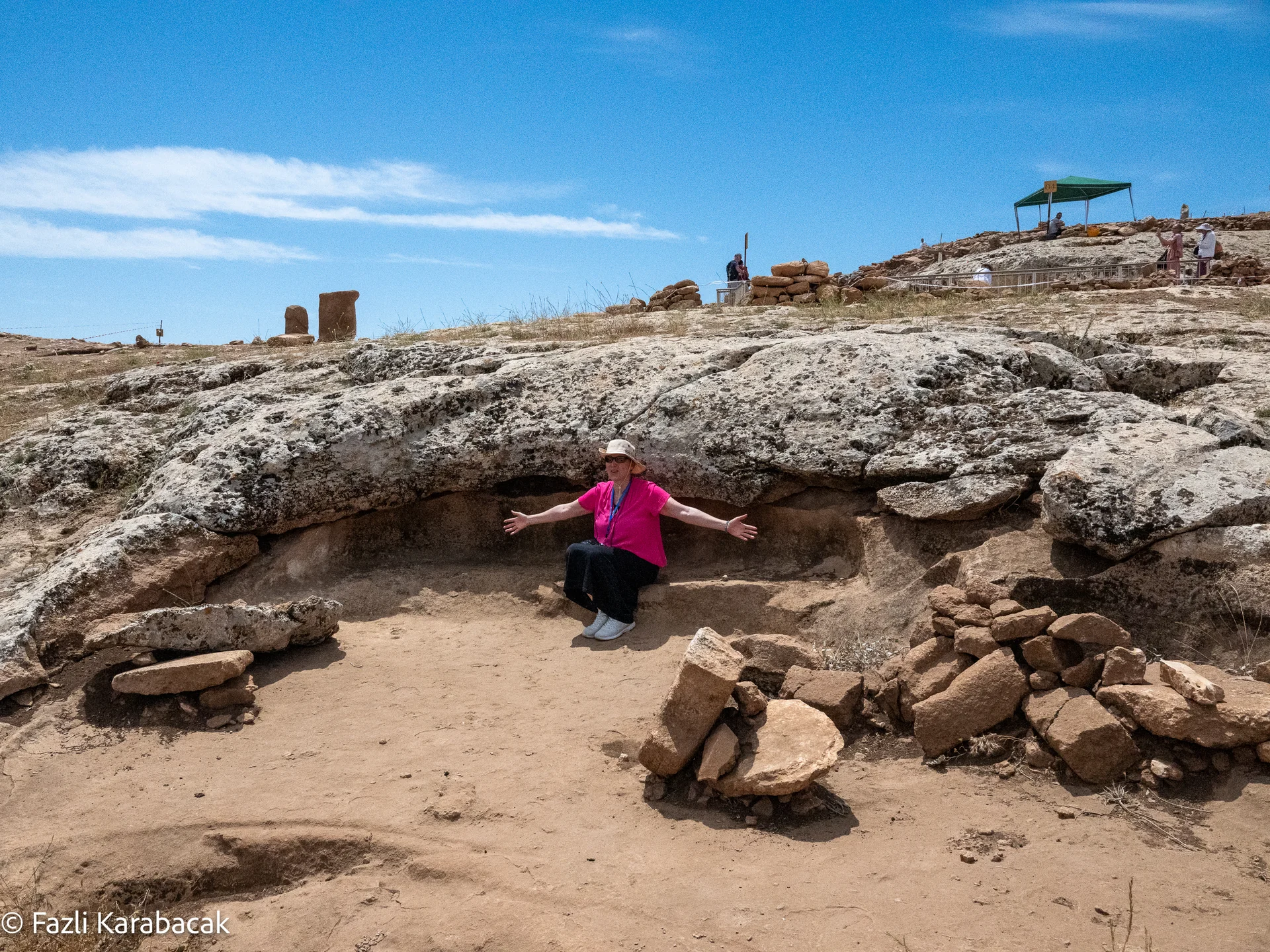
Limestone: The Material and the Medium
The limestone bedrock of the Tektek Mountains is not just the foundation of Karahan Tepe — it is the medium from which the site was created. The builders chose locations where the stone quality was suitable for large-scale carving. The Eocene and Miocene limestone in this region is relatively soft when freshly exposed and hardens over time — a characteristic that would have made it workable with stone tools.
The quality of the limestone varies across the site, and the builders appear to have understood these variations. Structure AD, with its massive buttresses and pillar arrays, is positioned where the bedrock is thick and consistent enough to support such ambitious carving. The unfinished monolith found at the site — 5.5 meters long, 15 metric tonnes — was abandoned where the stone quality may have proved unsuitable for extraction.
What the Landscape Tells Visitors
When I bring tour groups to Karahan Tepe, I always make a point of pausing before entering the archaeological area. I ask people to look around at the landscape and imagine it with more trees, more grass, more animals. The site does not exist in isolation — it was part of a living ecosystem.
I also draw attention to the sight lines. From Karahan Tepe’s hilltop, you can see for kilometers in every direction. In the Neolithic, when the regional population was sparse and communities were small, a place with commanding views would have held strategic and perhaps spiritual significance. You could watch the seasons change across the landscape, track animal movements, and observe the sky without obstruction.
The wind is constant here, and it carries a quality of emptiness that feels ancient. It is one of the things about Karahan Tepe that photographs never capture but that every visitor remembers.
Frequently Asked Questions
What type of rock is Karahan Tepe built on? Eocene and Miocene limestone, which is relatively soft when freshly exposed and hardens over time — making it workable with stone tools.
Was the climate different when Karahan Tepe was built? Yes. The region was significantly wetter and more vegetated during the Pre-Pottery Neolithic period (10,000–8,000 BCE) than it is today.
Why was Karahan Tepe built in such a remote location? The elevated position offered commanding views, defensible terrain, and high-quality limestone for construction. The area was also richer in resources during the Neolithic than it is now.
Is there water at the site? A large rock-cut basin on the northern knoll may have served as a water cistern. Today, the area is dry steppe dependent on seasonal rainfall.