Quick Answer
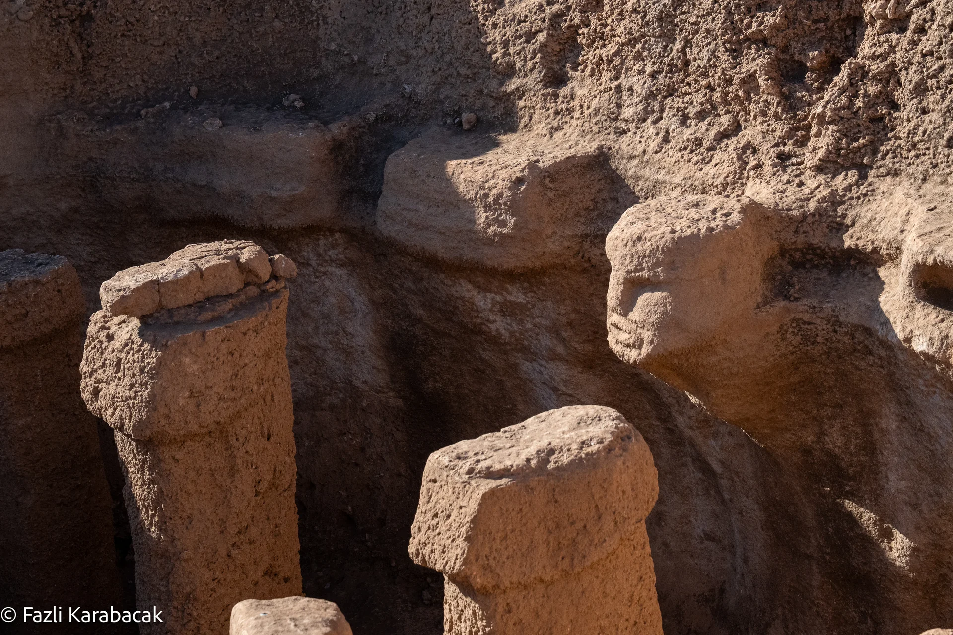
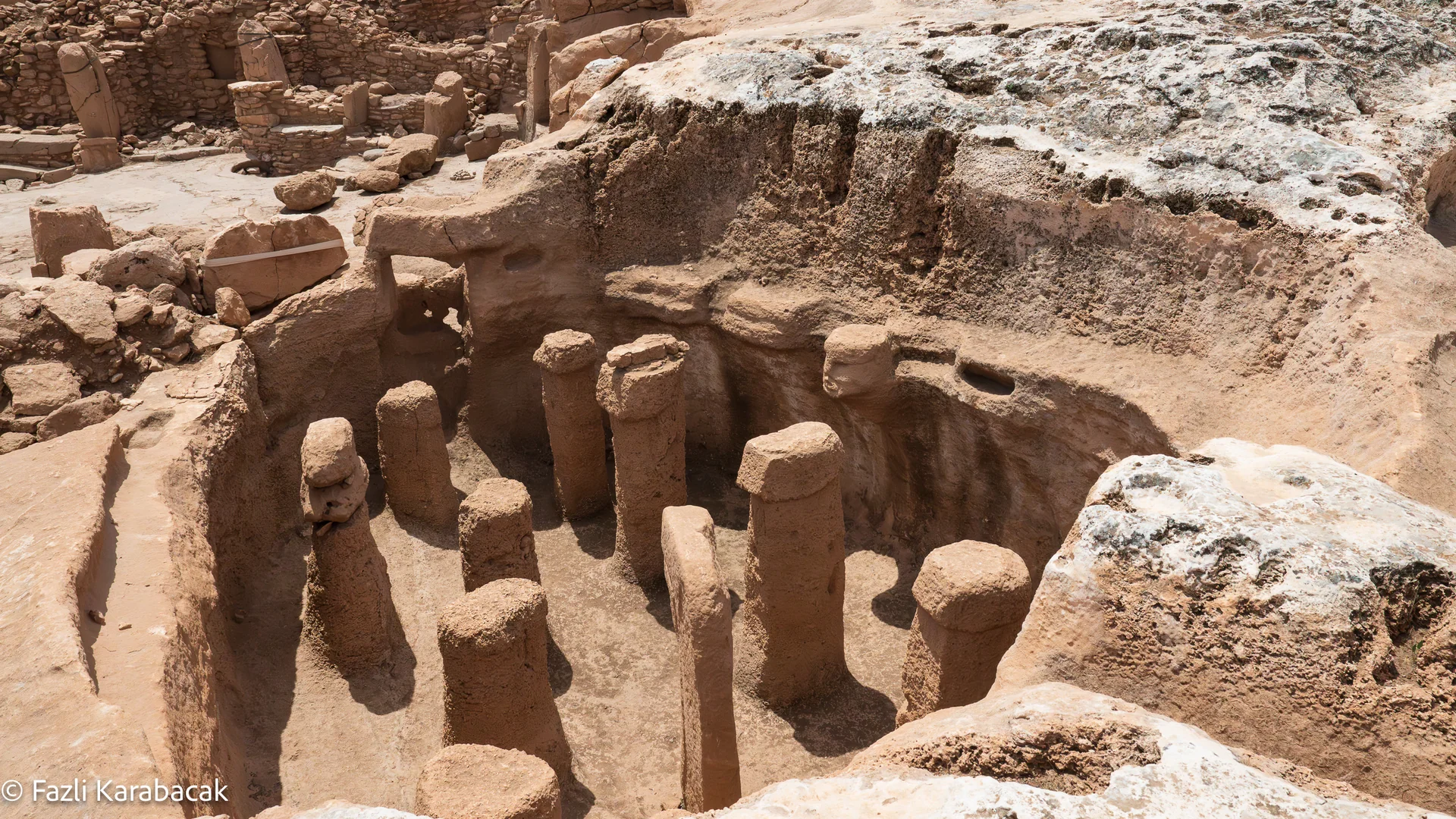
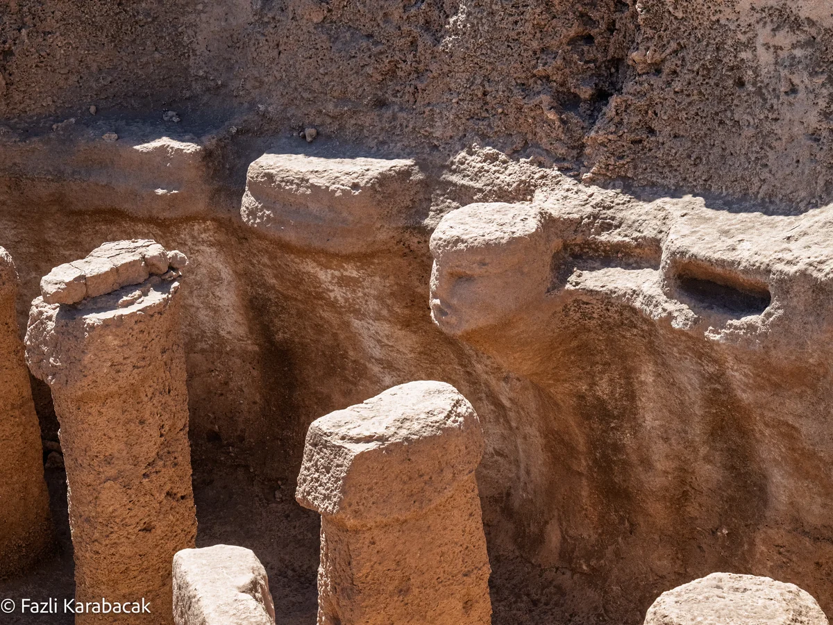
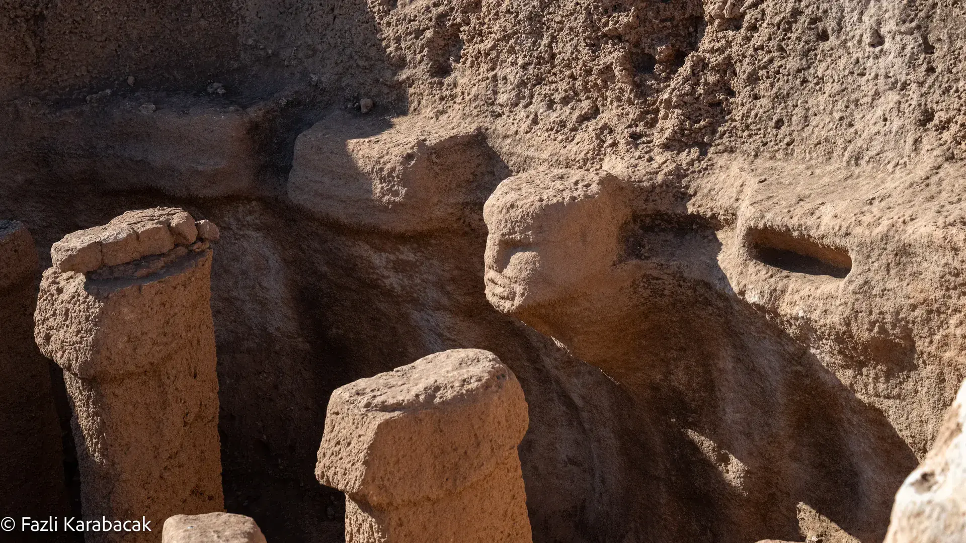
Karahantepe is a Pre-Pottery Neolithic settlement in southeastern Türkiye, broadly dated to approximately 9600–8000 BCE. Its communal and domestic architecture complicates a simple story of farming first, monuments later. Structure AB has ten phallic bedrock pillars, an inserted eleventh element and a human head projecting from its western wall. The 2.3-metre seated statue announced in 2023 is a separate find. Building functions, exact object dates and ritual meanings remain questions for contextual study, not facts that can be inferred from a headline.
Beneath the sun-scorched limestone ridges of Şanlıurfa in southeastern Turkey, archaeologists have uncovered a prehistoric settlement so vast and so sophisticated that it is fundamentally challenging long-held assumptions about the origins of settled life, monumental architecture, and social complexity in human history. Welcome to Karahantepe.
Table of Contents
- The Discovery: From Survey to Sensation
- Dating Karahantepe: When Was It Built?
- The Landscape: Why Here?
- Monumental Architecture: Structure AD
- T-Shaped Pillars: More Than Meets the Eye
- Special Purpose Buildings: Beyond the Temple Debate
- Symbolism, Sculpture, and the Inner World
- Daily Life: Diet, Settlement, and Social Organization
- Deliberate Burial of Buildings: Architecture as Living Memory
- Karahantepe and the Wider Neolithic World
- Why Karahantepe Matters
The Discovery: From Survey to Sensation
The story of Karahantepe cannot be told in isolation. It is part of a larger archaeological narrative that stretches back to the 1960s, when the Joint Istanbul-Chicago Prehistoric Project brought together two towering figures in Near Eastern archaeology: Robert Braidwood of the University of Chicago’s Oriental Institute and Halet Cambel of Istanbul University’s Prehistory Department.
In 1963, Braidwood and Cambel conducted an extensive surface survey across southeastern Anatolia, covering the terrain from Siirt to Şanlıurfa. Braidwood had already proposed his influential “hilly flanks” theory, arguing that the origins of agriculture should be sought in the natural habitats of the wild ancestors of domesticated plants and animals. Political instability had prevented him from continuing fieldwork in Syria and Iraq, so Turkey became the new frontier for testing his hypothesis.
That 1963 survey identified dozens of sites, including, remarkably, Göbekli Tepe. The team recognized Neolithic flint tools on the surface and noted the tips of large stone pillars protruding from the ground. However, the pillars were deemed too monumental for a Neolithic context, and the decision was made to excavate Çayönü instead, a site on the plains considered more likely to yield evidence of early farming. Çayönü would go on to become one of the most important Neolithic excavations in Southwest Asia, but Göbekli Tepe would have to wait three more decades for its moment.
The next milestone came in the 1990s with the excavation of Nevali Çori, a Pre-Pottery Neolithic B site near Bozova in Şanlıurfa province. Directed by Harald Hauptmann of Heidelberg University, Nevali Çori yielded monumental buildings adorned with carved pillars and remarkable sculptures, marking the first time T-shaped pillars with human-like features were recognized at a Neolithic site. Unfortunately, the site was submerged by the rising waters of the Atatürk Dam reservoir, though key architectural elements were salvaged and relocated to the Şanlıurfa Museum, where they remain on display today.
It was a member of the Nevali Çori team, Klaus Schmidt of the German Archaeological Institute, who revisited Göbekli Tepe in 1994 and recognized the significance of the pillar fragments on its surface. Excavations began in 1995 and continued without interruption until Schmidt’s untimely death in 2014, revealing an archaeological site of unprecedented scale and ambition.
Meanwhile, in 1997, a systematic survey led by Bahattin Çelik of Harran University identified Karahantepe as part of a broader inventory project sponsored by the Turkish Academy of Sciences. Though earlier travelers and archaeologists had photographed the site in passing, its formal entry into the archaeological literature dates to this survey. Karahantepe was not alone: the survey documented numerous other contemporary sites in the region, demonstrating that Göbekli Tepe was far from an isolated phenomenon.
Key Timeline
- 1963 — Braidwood-Cambel survey discovers Göbekli Tepe and other sites
- 1964 — Çayönü excavations begin
- 1990s — Nevali Çori excavation reveals first T-shaped pillars
- 1995 — Klaus Schmidt begins Göbekli Tepe excavations
- 1997 — Bahattin Çelik’s survey formally identifies Karahantepe
- 2019 — Systematic excavations begin at Karahantepe under Necmi Karul
- 2021 — The Taş Tepeler initiative launches; Karul publishes the Structure AB filling study
- 2023 — The Ministry announces a separate 2.3-metre seated statue
Dating Karahantepe: When Was It Built?
To understand when Karahantepe was occupied, it helps to zoom out. Communities across Southwest Asia were developing more settled ways of life before the Neolithic. The Younger Dryas, a late-glacial cooling episode, lasted approximately 10,900–9700 BCE; 9700 BCE marks its end, not its beginning.
From approximately 9600 BCE onward, as temperatures warmed again, the region around Karahantepe and across Southwest Asia saw an acceleration in permanent settlement. Sites multiplied, populations grew, and communities began constructing increasingly ambitious architectural projects. This era corresponds to the Pre-Pottery Neolithic (PPN), the period before the invention of fired ceramics.
The Pre-Pottery Neolithic is conventionally divided into sub-phases, including PPNA and PPNB; exact boundaries vary by regional framework. Karahantepe’s commonly cited range of approximately 9600–8000 BCE is a broad occupation chronology. It does not establish 1,500 years of uninterrupted use for every building or a precise date for every sculpture.
Dating evidence and comparison of tools and architecture place Karahantepe and Göbekli Tepe in the same broad Neolithic world. Oxford’s radiocarbon guide explains that the method dates organic material, not the carving of limestone. Charcoal or bone dates constrain a building or object only when their archaeological relationship is understood.
The Landscape: Why Here?
The Tektek Mountains, where Karahantepe is situated, belong to a tectonically active zone where the African, Arabian, and Eurasian plates converge. This geological collision built the Taurus Mountains, which form a natural barrier between the arid landscapes to the south and the cooler, wetter highlands to the north.
The bedrock in this region consists predominantly of Miocene-era calcium carbonate (limestone) formations, exposed as sea levels dropped over the past 20 million years. These limestone pavements have weathered into gently undulating hills covered with thin soils. From above, the terrain resembles a series of egg-shaped mounds, each capped with eroded rock slabs.
This geology was critically important for Neolithic builders. Limestone is relatively soft and easy to quarry, making it an ideal material for carving the massive T-shaped pillars directly from the living bedrock. The monolithic pillars found at Karahantepe and neighboring sites could be extracted as single pieces from the rock surface, a feat made possible by the layered structure of the local limestone. This geological advantage likely explains why T-shaped pillars appear exclusively in the Şanlıurfa region.
But raw material was not the only draw. In the early Holocene, following the end of the Ice Age, the landscape was far more lush than today. Valleys filled with water, creating streams and lakes. The vegetation was dominated by sparse oak woodland interspersed with wild almond and wild pistachio (terebinth). Within remarkably short distances, different ecological niches supported diverse animal populations: wild cattle, deer, and waterfowl in the lowland plains of the Harran basin; gazelles, wild sheep, and wild asses on the higher ridges. This ecological diversity made the region ideal for hunter-gatherer communities, providing abundant and varied food resources within easy reach.
Monumental Architecture: Structure AD
Structure AD, often called the Great Ellipse, is a large oval enclosure. The plan discussed in our three-room guide is approximately 23 by 20 metres. Measurements should be tied to the particular wall line and phase being described, rather than treated as interchangeable diameters. Its size suggests substantial gatherings, but a precise seating capacity is an estimate, not a population count.
Structure AD was built into a hillside. On the uphill side, the wall was carved directly from the bedrock. On the other sides, massive stone walls were constructed to define the enclosure. The floor was meticulously leveled from the natural limestone, producing a smooth, even surface. Along the interior walls, two-tiered stone benches (called “sekis”) were installed, some hewn from the bedrock, others assembled from large flat stones. Eighteen T-shaped pillars were integrated into the walls (seventeen embedded within the wall itself, one positioned just in front), and two taller central pillars stood facing each other in the middle of the space.
The Challenge of Roofing
Roofing such a large space is an important reconstruction question. Pillars, sockets, ledges and any surviving building materials can inform a model, but dimensions and stability need engineering assessment. A shallow socket alone does not prove a particular roof form or make an alternative physically impossible.
One possible reconstruction uses central supports and timber beams with lighter roofing materials. This should be presented as a model, not as a preserved roof whose exact form is known.
Architectural Renewal: Walls Within Walls
Building modifications can change the usable interior and the relationship between pillars, walls and benches. Reused stones and successive wall lines therefore matter when comparing published plans. Exact durations or a sequence of three century-long renovations require phase-specific evidence and should not be assumed from the appearance of a plan.
T-Shaped Pillars: More Than Meets the Eye
The T-shaped pillars are the signature feature of Karahantepe and its sister sites. Their scale and carved attributes raise questions about both structural and symbolic roles.
Pillars could have supported roofing while also carrying symbolic meaning. Arms, hands and clothing details on examples in the wider region support a human interpretation. A human face on a T-shaped pillar reported in 2025 adds evidence to that reading; it does not reveal the identity of the figure or prove a particular religion.
The lateral faces of many pillars served as what might be described as narrative canvases. Animal figures, including leopards, snakes, foxes, gazelles, and birds, were carved in relief or incised into the stone. Some panels combine multiple figures and geometric motifs into complex scenes that appear to tell stories, possibly mythological narratives familiar to the community. These motifs have been described as potential precursors to writing, visual storytelling systems that conveyed shared cultural knowledge.
Feline and serpent imagery are important themes, but ranking one as the site’s most common motif requires a defined catalogue and consistent counting. Symbolic meaning cannot be recovered from frequency alone.
Notably, T-shaped pillars are found exclusively in the Şanlıurfa region. While other Neolithic sites in the Tigris basin and beyond feature standing stones, mud-brick pillars, or carved stelae, the specific T-form appears to be a regional phenomenon, likely tied to the particular limestone geology that made their extraction feasible.
Special Purpose Buildings: Beyond the Temple Debate
For decades, scholars have debated what to call these monumental Neolithic structures. The word “temple” was widely adopted following the early publications on Göbekli Tepe, but this label carries significant theoretical baggage. To call a building a temple implies the existence of an organized religion, a priestly class, codified rituals of worship, and a religious economy. None of these can currently be demonstrated for the Pre-Pottery Neolithic period.
At Karahantepe, the excavation results have pushed this debate further. The communal buildings are not all identical. They vary in size, plan, and interior features, suggesting different functions rather than repetitions of a single sacred formula. This diversity is crucial: if they were all temples, which one would be the temple? Their differences suggest a range of communal activities rather than a single religious purpose.
A more productive framework views these buildings as multi-functional communal gathering spaces. In a period when human groups were for the first time living together in unprecedented numbers, these structures served as places where the community assembled for collective decision-making, ritual performance, storytelling, perhaps music, and the reinforcement of shared identity. This interpretation does not deny the existence of belief systems. Clearly, these communities possessed sophisticated symbolic and ritual practices. But it distinguishes between the broad category of shared beliefs and the specific institution of organized religion with all its structural apparatus.
The Phallus Chamber
Structure AB contains ten phallus-shaped pillars carved from bedrock, with a separately inserted eleventh stone element. Four front pillars stand 1.6–1.7 metres high; six rear pillars stand 1–1.4 metres high. A human head projects from the western wall near two small niches. Karul’s 2021 report (PDF) records primary entry from AD and a connection from AB to AA, and proposes a ceremonial sequence as a preliminary interpretation.
Karul also records a serpentine channel opening into AB from the north. This describes a winding feature, not a confirmed snake relief. Its presence does not by itself establish a complete hydraulic system, a liquid-level sequence or a particular ritual.
The Kitchen and Feasting Area
On the opposite end of Structure AD, another attached room contained ovens and large quantities of animal bones, including near-complete skeletons. This space clearly served a food preparation function, possibly linked to communal feasting events held in the main hall. Together with the phallus chamber and the central gathering hall, these interconnected spaces form a communal building complex with distinct functional zones.
Symbolism, Sculpture, and the Inner World
Ancient interiors need not have resembled today’s bare ruins. The Ministry’s 2023 announcement reports red, white and black pigment on a boar sculpture from Göbekli Tepe. That find is separate from the seated human statue reported at Karahantepe in the same announcement.
Pigment on one object does not establish that every relief or sculpture was painted. Organic furnishings and lighting can be explored through reconstruction, but they should be labelled as possibilities rather than a recovered interior scene.
Sculpture and architecture need to be studied together. But an empty niche does not establish that it once held an image. In AB, the two niches recorded beside the western-wall head should not be turned into additional sculpted faces or a complete series of animal installations.
The Question of Gender in Symbolism
Among the identifiable sculptures and reliefs found at Karahantepe and its contemporary sites, virtually all depict male subjects. The phallic installations are the most explicit expression of this, but it extends to human and animal representations alike. This has raised questions about whether feminine symbolism was absent from these communities.
Ethnographic parallels suggest that masculine symbolism tends to be expressed through durable materials (stone, bone), while feminine symbolism is often associated with perishable organic materials (textiles, wood, plant fibers). If female-associated symbols were rendered in materials that do not survive in the archaeological record, their apparent absence may be an artifact of preservation rather than a reflection of social reality. Supporting this interpretation, later phases of the Neolithic in the same region show a marked increase in female figurines, suggesting continuity rather than sudden appearance.
The Separate 2.3-Metre Seated Statue
The 30 September 2023 Ministry report gives a height of 2.3 metres for a seated statue fixed into a bench, with prominent ribs, spine and shoulder bones. A vulture sculpture and stone plates were found in the same area. This is the Sitting Man, not Structure AB’s wall head. The report does not establish an exact carving date or an “oldest realistic statue” ranking. Life-and-death interpretations remain hypotheses about its meaning.
Daily Life: Diet, Settlement, and Social Organization
What Did They Eat?
Faunal analysis from Karahantepe reveals a community deeply engaged in hunting. Gazelle is important in accounts of the faunal assemblage, but a percentage must be tied to a particular identified sample and publication. Wild asses, foxes, and wild sheep follow in frequency, with smaller quantities of wild cattle, red deer, fish (including carp), and turtle. This dietary profile differs notably from Göbekli Tepe, where wild cattle played a larger role, reflecting the distinct ecological niches exploited by each settlement despite their proximity.
Cereals, pulses and nuts are important to the wider regional Neolithic subsistence picture. Establishing Karahantepe’s precise plant diet or a transition to domestication at a particular date requires a site-specific botanical study. Grinding stones suggest processing activities, while a vessel residue needs analysis before identifying a food or drink.
The evidence complicates a universal sequence in which farming necessarily came before settlement and communal building. Hunting, gathering, cultivation and domestication developed in different combinations across the region; they should not be reduced to a single cause-and-effect rule.
Settlement Layout
Approximately 6,000 square meters have been excavated at Karahantepe, revealing a settlement pattern in which communal buildings occupied a central or edge position, surrounded on at least three sides by smaller domestic structures (houses or “huts”). These domestic buildings share common walls in an agglutinated layout, meaning new rooms were added by building onto existing walls rather than standing as freestanding structures, much like a honeycomb.
The domestic buildings were semi-subterranean, their floors set below the walking surface. Entry was typically from above, through the roof. Stone staircases have been found at Karahantepe (one with six steps), and wooden ladders likely supplemented these where stone was impractical. Groups of domestic structures appear to have shared a common roof, supported by evidence including shared walls, interior wooden post sockets, and drainage systems that would only function under a unified roof covering.
One reconstruction imagines larger roofs over communal buildings beside lower domestic rooms. It is an architectural model, not an eyewitness view of the settlement; alternative roof arrangements need testing against the evidence.
Population
Estimating population is difficult. Site area, the capacity of a communal building and the number of houses used at the same time are different measures. They require phase-specific evidence before they can support a population estimate; an assumed seating capacity is not a census.
Deliberate Burial of Buildings: Architecture as Living Memory
One important excavation argument concerns intentional filling in Structure AB. Karul’s 2021 study uses stratigraphy and the placement of stones to distinguish that building’s filling from natural accumulation. This does not establish one simultaneous burial event for the whole settlement.
In the phallus chamber, the process followed a clear sequence: first, a layer of distinctive red soil was spread across the bedrock floor. Then a mixed fill of stones and earth was poured in. When the fill reached the level of the phallus tops, flat stones were carefully placed directly over them. As the fill approached the surface, large flat slabs were selected to seal the building. These layered, spatially specific actions cannot be explained by erosion or earthquake debris.
Other buildings require their own stratigraphic assessment. Filling can involve deliberate deposition, collapse, later disturbance and natural processes in different combinations; evidence from AB should not be copied onto an unnamed building or an unspecified “most recent season.”
Objects in filling deposits may help explain how a building was closed, but a ritual interpretation requires a securely documented association. Exact inventories and the order of deposition must come from the relevant building report, not from a general narrative about the site.
A building can be read as having a biography: construction, use, alteration and closure. This is an interpretive analogy, not a quotation from the builders or proof of a specific belief.
Karul discusses closure as a possible way of preserving a building’s references to the past. This is an important interpretation, but demonstrating uninterrupted memory or a site-wide rule against building over earlier structures requires evidence beyond AB’s filling sequence.
Karahantepe and the Wider Neolithic World
Karahantepe was not an island. Obsidian, which does not occur naturally in the Şanlıurfa region, has been found at the site, demonstrating trade connections with sources in eastern Anatolia (likely Bingöl or the area around Lake Van). Marine shells found in burials at contemporary sites indicate exchange networks reaching the Mediterranean or possibly the Red Sea. The technological profile of Karahantepe’s flint tool industry shows clear parallels with Levantine traditions, connecting the site to a broader Eastern Mediterranean sphere of interaction.
The intensity of communication correlated with proximity. Neighboring settlements within the Şanlıurfa region shared the same symbolic vocabulary, the same T-shaped pillar tradition, and similar architectural techniques. Further afield, in the Tigris basin at sites like Körtik Tepe, Gusir Höyük, and Çayönü, communities developed their own parallel trajectories, with standing stones and communal buildings that shared some features with the Şanlıurfa tradition but also displayed distinct regional characteristics.
The Taş Tepeler Project coordinates research across multiple sites and institutions. Season-specific participation totals should be dated to their announcement rather than presented indefinitely as “the most recent season.”
Why Karahantepe Matters
Karahantepe matters because it dismantles comfortable narratives. For decades, the story of human civilization was told as a linear progression: first came farming, then permanent settlements, then social complexity, then monumental architecture, then religion. Karahantepe, together with Göbekli Tepe and the broader Taş Tepeler network, inverts this sequence. Here, monumental buildings, sophisticated art and social organisation developed amid changing relationships between wild resources, cultivation and settled life. Communities of hunter-gatherers, sustained by wild resources, built structures requiring coordinated labor, specialized craftsmanship, and shared cultural narratives on a scale previously thought impossible without an agricultural surplus.
The site also challenges the “Göbekli Tepe singularity.” For years after its discovery, Göbekli Tepe was presented as a unique, isolated ritual center to which scattered bands of nomadic hunters periodically journeyed. Karahantepe, with its 14-hectare settlement area, its domestic architecture, its communal building complex with multiple functional zones, and its satellite settlements, demonstrates that this was a region of dense, permanent habitation. Domestic evidence matters alongside communal architecture. “Settlement” and “ceremonial place” need not be mutually exclusive categories.
Perhaps most profoundly, Karahantepe reveals the depth of the human impulse to create meaning through built space. Twelve thousand years ago, on a limestone ridge above the Mesopotamian plain, communities invested extraordinary effort not just in building monumental structures, but in maintaining them, renewing them, decorating them with narrative art, and ultimately burying them with ceremony and care. The buildings were not merely functional. They were participants in social life, repositories of collective memory, and expressions of a worldview in which the boundary between the living and the dead, between people and places, was far more fluid than modern categories allow.
Excavations continue, and each season brings new revelations. With only a fraction of the site uncovered, Karahantepe promises to remain at the forefront of Neolithic research for decades to come, one layer at a time, revealing the extraordinary capabilities of our earliest settled ancestors.
Frequently Asked Questions
How old is Karahantepe? Its broad chronology is commonly given as approximately 9600–8000 BCE. Individual buildings and sculptures require contextual dating; this does not establish that every Karahantepe feature is older than its Göbekli Tepe counterpart.
What percentage of Karahantepe has been excavated? As of 2025, less than 5% of the site has been systematically excavated. The site covers approximately 14 hectares, and satellite settlements extend the occupied area further.
What is the largest structure at Karahantepe? Structure AD, the Great Ellipse, is a major communal enclosure, approximately 23 by 20 metres in the plan discussed here. Measurements must identify the wall line and phase; exact seating capacity remains an estimate.
What’s the difference between Karahantepe and Göbekli Tepe? Both combine built elements with bedrock features. Karahantepe’s connected rock-cut rooms offer a distinctive comparison, while habitation and communal activity must be considered at both sites.
Why does Karahantepe matter more than Göbekli Tepe? Karahantepe doesn’t matter “more” — they’re complementary sites. Karahantepe challenges the “Göbekli Tepe singularity” by proving that monumental construction, complex social organization, and sophisticated ritual were not isolated phenomena but part of a dense regional network of settlements.
What does Karahantepe tell us about the origins of civilization? It challenges simple sequences: communal building, domestic life, hunting, gathering and cultivation need to be studied together rather than assigned one universal order.
Sources and Further Reading
- Necmi Karul’s 2021 Structure AB report (PDF): architecture, wall head, pillars and the interpretation of intentional filling.
- Ministry of Culture and Tourism, 30 September 2023: separate discoveries of a painted boar at Göbekli Tepe and a seated human statue at Karahantepe.
- Oxford Radiocarbon Accelerator Unit: dating: what radiocarbon can and cannot date.
- Visitor guide and structure overview: practical planning and find-by-find context.